
“Not ideal, is it mate?”
We’re probably about a third of the way through the 300-metre ascent to the high ridges of the Heavitree Range, and Anne is looking worried.
“Definitely not ideal,” I laugh. “But I’ll get there.”
“It’s not too late,” she says. “You can turn back and I can get Holger to come and pick you up.”
“Nah it’s okay. Honestly, I’m sure I’ll be right.”
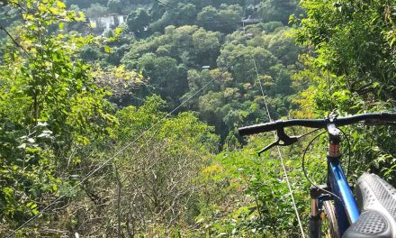
She doesn’t look completely convinced, but she lets it go and I hobble on. Eventually, I make it to the ridgeline where the group has gathered. It’s immediately obvious why they’ve chosen to stop here. They’re as awestruck as I now am, at the sheer rocky cliffs on the opposite side of the range, and the rugged, perfectly U-shaped valley at their base.
I’m glad to have made it up here for this view but unfortunately, I can already feel my left leg tightening up. I’ve been hugely overcompensating for my knee, and it’s getting pretty sore. For the next four kilometres along the ridgeline, I’m concentrating so hard on where to put my feet (and my pole) that I have to force myself to stop periodically and enjoy the landscape. I’m still loving being up here but, by the time we reach our lunch spot at Counts Point Junction, I’ve decided to skip the side trip to the lookout.
Anne is just about to make the same suggestion when I tell her of my decision.
“But that’s okay,” she grins. “You can stay here and help with lunch.”
The group takes off, leaving Anne and I to hang out and have a good chat while she sets up lunch. She even refuses my offers of help.
As I sit watching the tiny figures disappear up Counts Point, I know I’ve made the right decision. I still need to make it back off the range.

The rocky ridge of the Heavitree Range.

Having a break overlooking the valley.

Ancient wave ripple marks are visible all over the Heavitree Range.

Anne mostly sticks with me throughout the descent.

Some of the terrain on the way down is
tricky with a bung knee.

On our last two nights we’re planning to camp at a public campground
at Finke River, but at the last minute Elise discovers that Trek
Larapinta’s private Pioneer River campsite isn’t currently
in use. It’s a beautiful spot and a nice surprise.

I consider opting for my swag anyway, but when I realise there are
stretcher beds in the safari tents, I can’t resist the luxury.
***
I awake on the morning of day five to movement around the campsite and decide I’d better get up and limp my way to breakfast.
If I hadn’t already decided yesterday that I wouldn’t be walking today’s 29 kilometre slog, then waking up in agony every time I rolled over during the night would have definitely made that decision for me. It’s a slightly depressing state of affairs, but I’m afraid that if I push it I might end up in surgery. Even worse, I’m worried that I’d end up with a helicopter ride before I made it through such a long hike.
The hikers have already left us to have a nice sleep in, but I’m not the only one sitting out day five so I join the others around the fire. Another guest called Anne is injured too, and Sue has decided she’d just prefer a relaxing day.
“I’d have never considered doing that, but it’s great that we’ve got that option,” I remark.
Elise joins us at the fire and we have a chat about what to do with our day. We’ve been told we’re not far from Glen Helen Resort, which has a payphone and showers, so that’s my main goal. We decide to head to Ormiston Gorge for a look, as well.
On our arrival at Glen Helen, I pay my $5 (yep, five bucks for a shower, because they can), grab a towel and make a B-line for the showers. Watching the brown water swirling down the drain is all the confirmation I need that it’s the best $5 I’ve ever spent.
Refreshed, I call Lori and break the news of what I’ve done to myself. I’m half expecting her to tell me how stupid I was for hiking on day four, but she’s just as ecstatic to hear my voice as I am to hear hers, so even if she is thinking I’m an idiot she resists the temptation.
We move on to Ormiston Gorge, where Elise takes Sue for a short walk on the Ghost Gum Loop. Anne and I opt to hang out at the café for a coffee and snack, and then very slowly walk down to the Ormiston Waterhole to sit and take in the birdlife.
Before long, we’re heading back to camp where I spend the afternoon writing, reading and relaxing in the sunshine. I even have time for a siesta. I came here to hike the Larapinta Trail but, even if I can’t do any more of that, the alternative is pretty sweet.

The Orminston Waterhole.

The local dingoes have come to visit our campsites on most nights of the trip, but it’s not until Orminston Gorge that we find one willing to come close enough for a photo.

A Sacred Kingfisher watched over Orminston Waterhole.
***
The sound of my tent flapping in the wind interrupts my siesta. I check the time and see that the group is due back soon, so I slowly hobble my way back up to the fireplace. By the time I get there, I hear them roll up the driveway.
They exit the 4WD all looking a bit stiff but far better than I’d imagined. David and Leigh head straight to the fridge for a beer, and everyone takes a seat.
“How’d you go, James?” I ask.
“Yeah, it was awesome,” he says. “But I didn’t get any reception, so at least you didn’t miss that.”
I laugh. James and I have been the most obviously gadget-addicted in the group since day one, searching for phone reception upon reaching every peak along the trail.
“What about everyone else?” I ask.
“It was a spectacular day’s walk,” says Leigh, groaning and stretching. “But it was just five k’s too long. The last five were beautiful, but it was just hard to appreciate them.”
“Those last few undulations were just unfair,” adds David.
“We saw some amazing geology,” Anne remarks. “My favourite part was walking up the U-shaped valley that we saw yesterday, with Mount Sonder there in the distance.”
I’m satisfied that at least now I’ve got something to tell my readers about day five. There’s a minute of silence and then James turns to Leigh.
“How’s that beer going down?”
Leigh points at his beer can. “Aahhh, God did good… when she created beer.”

The U-shaped valley on section 9 (photo by Margaret Carr).

Some of the stunning geography from Section 9 (photo by Margaret Carr).
As the sun sets, we hang out and chat around the fireplace over a couple more beers and a Massaman curry, and then Elise and Anne join the group to brief us about tomorrow’s hike to Mount Sonder for sunrise. I listen in, staring into the fire and growing more and more disappointed as Elise tells us what to expect – the changing colours and the cone-shaped shadow that Mount Sonder casts on the desert as the sun creeps over and everything comes to life.
When she’s finished I start grabbing everyone’s dishes and head off to start washing them. Anne grabs some too and follows me over to f, help.
“You a bit sad about tomorrow, mate?” she asks.
“Yeah I’m a bit shattered, hey.”
“Ah well, we’ll look forward to seeing you back next year. She’s not going anywhere.”
“That’s exactly right,” I chuckle. “She’s been there a while.”
I don’t know if it’ll be next year, but I’ll sure as hell be back. I feel like something will be missing when I leave.

The group was quiet on their return from Sonder, no doubt exhausted from the 2 am wakeup, so I’ll let the pictures do the talking. Here they are waiting for sunrise on Mount Sonder with a cuppa (photo by Margaret Carr).

Margaret taking in the sunrise (photo via Margaret Carr’s camera).

The cone-shaped shadow of Mount Sonder (photo by Margaret Carr).
Missed part 1 and 2 of this story? Click here to go back and start at the beginning.
Neil was a guest of Trek Tours Australia on this hike. This does not influence the views put forward here in any way.
Super 6 Day: The Larapinta Trail Challenge – Trek Tours Australia
This 6-day guided trip from Trek Tours Australia takes in the six most challenging sections of the trail (sections 3, 4, 5, 8, 9 and 12). It’s a fantastic way to take on some of Larapinta’s most challenging terrain and enjoy its most spectacular scenery, without the need to thru-hike the entire trail (although I would like to do that one day), or carry your own equipment, food and water. This is a contender for my favourite hiking trip of all time. I can’t recommend it highly enough.
Length (km): 107 km (13 km / 17 km / 17 km / 15 km / 29 km / 16km).
Time: 6 days (7 – 12 hrs hiking per day).
Grade: Difficult.
Region: Northern Territory.
Parks: West MacDonnell National Park.
Further Info: Pickup is from accommodation is Alice Springs. Camping equipment is included in the tour price. See the Trek Larapinta website for full details and pricing.
Hiked all or part of Larapinta yourself? Got questions about my experience with Trek Tours Australia? If you have any stories, questions, updates or corrections, please let us know by commenting below.


Hey Amanda, I just stumbled across this comment. No idea how I missed replying at the time. Anyways, it’s been 3 years… Got there yet? Omg what I’d give to go back now. Hope you’re well!
Looks great and it is definitely on my list. It is quite different terrain from any of the bushwalking that I’ve done.
It is pretty unique up there, Ken… I reckon the closest I’ve ever hiked to that terrain was the Colca Canyon in Peru. Makes for interesting hiking!
Cheers
Neil
Despite hurting your knee and not being able to walk the whole trek it looks like you still got a lot out of the experience Neil. I have had a few trips where I haven’t got to do all I wanted but it just leaves reason to go back again one day. Thanks for sharing what looks like an amazing trip Neil. You and Caro have definitely pushed the Larapinta into my top 5 bucket list of walks I want to do in the next few years 🙂
I definitely did, and yep you’re totally right… I’ll get back there one day for sure.
Great to hear Larapinta is moving up the list. 🙂 I seriously think it’s the most awesome trail I’ve ever hiked.
Thanks for your comments!
Cheers
Neil