Last Visited: 06/12/2009
Length (km): approx. 7 km (according to MapMyHike.com)
Time (hrs/min): 1 hour 20 mins
Grade: Moderate
Return / Circuit / One-Way / Partial Circuit: Circuit
Region: Melbourne
Park: Dandenong Ranges National Park
Closest Town: The Basin
Maximum Elevation: approx. 507 m (according to MapMyHike.com)
Total Ascent: approx. 205 m (according to MapMyHike.com)
Further Details / Source(s): The hike I intended to do was titled “Channel 10 Track / Camellia Loop” in the ParkWeb Park Note: Dandenong Ranges National Park – Visitor Guide. However it is listed there as being only 3.6 km, so I must have taken a different route.
Car Access: The hike starts and finishes at the Doongalla Homestead and Stables Picnic Ground, which is accessed via Simpsons Road, The Basin. Once through the gates, drive past the two picnic grounds and park in the carpark at the end of the road. Channel 10 Track begins here (Melways Ref: 66 D5).
This is one of the nicer spots I’ve found in the Dandenong Ranges National Park, so I’d highly recommend it for anyone looking for a short day walk not too far from Melbourne. Begin with a fairly steep ascent on Channel 10 Track, heading to the left at the first major track intersection (Dandenong Creek Track).

Part of Dacite Track
This track becomes Dacite Track at the intersection with Zig Zag Track, so keep going straight. I was nearly wiped out here by a huge group of mountain bikes coming down Zig Zag Track at speed. The tire-tracks along Camelia Track (and the unofficial tracks intersecting) suggest that the area is popular for mountain biking, so it wouldn’t hurt to keep your ears peeled.
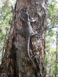
Descend Dacite Track carefully as it’s very steep and hard to keep your footing until it makes a sharp left. This is the point where it becomes Camelia Track and also where I had my most exciting Australian wildlife encounter so far (not that this is saying very much)… I was shocked when I saw something out of the corner of my eye and thought something (or someone!) was jumping out at me. It was just a Lace Monitor (aka Lace Goanna) that had obviously seen me coming and ran up a tree! It growled and hissed at me, so I took a few quick close-up shots and decided to watch from a distance. Eventually, it came down from the tree and slinked off into the bush. What an amazing creature! It must have been about 1.5 metres from nose to tail!

The Lace Monitor
Camelia Track will lead you straight back to the road you drove in on, so just make sure you take a left to head back up to your car. Though the Lace Monitor was definitely the highlight of this outing for me, this beautiful Dandenongs walk isn’t as busy as many visitors as other parts. I’d highly recommend checking it out.
Have you visited the area around Doongalla Homestead yourself? If you have any stories, updates or corrections, please let us know by commenting below.


Awesome tips thanks Neil. Was a great hike!
Glad to hear you enjoyed it, Steven!
Planning on doing this Walkex a family today. Thanks Neil for your detailed notes. Thanks Helen for the tip about the Melways map. It is much more detailed.
Nice one Natasha! Glad the blog post and comments were helpful. 🙂
Cheers
Neil
Hi,
I am planning to take this walk (Channel 10 Track/Camellia Loop) on Good Friday. Do you have a good map to refer?
Thanks,
Harihara Madavan
Hi Harihara,
I did this walk using the map in the Parks Victoria park note (www.parkweb.vic.gov.au), which is what I based the map in this post on.
Cheers
Neil
Hi Neil,
The mapstart link you have provided is very useful. Will try to explore more tracks this weekend. Day before yesterday I explored the Ridge Track and Banksia Track and a bit of Bradley track. The forest is really awesome. This is also well marked.
Public Transport: Take Belgrave train and get down at either Bayswater or Boronia. Take bus route no 755 and get down at Mountain Hwy Basin. From there you will have to walk around 2 kms to reach the Doongalla Forest.
From Mountain Hwy, take the Basin – Olinda Road and then the Sheffield Road. Then take the Doongalla Road. After a bit of walk on the Doongalla Road, you will see one board for Basin Theatre and a deviation towards left. Take the deviation and walk for 300 – 400 m to reach the Ridge Track in Doongalla Forest.
Thanks,
Harihara Madavan
Hi again Harihara,
I’m so glad you’re enjoying so many of the walks. Thanks heaps for adding the public transport info, too!
Cheers
Neil
Hi Neil,
There are so many tracks in the Doongalla Forest and if you are interested I can collate information on couple of 2-3 hrs hiking routes and email you. I am now following the map provided in the mapstart link. That is a lot useful for this Doongalla forest walk.
Today I explored the following:
Edgar Track – Unofficial Rocky track – Camelia Track – Doongalla Forest Road – Stables Track – Bills Track – Edgar Track – Invermay Track – Trace back to Edgar Track
Thanks
Harihara Madavan
Hi Harihara,
Thanks very much for the offer. If you’re interested in contributing a guest post on a walk you’ve done, you’re more than welcome to do so. I’d need at least 300 words and 4 or more photos. I’d be willing to accept one to begin with, but possibly more in the future.
Thanks
Neil
Hi Helen,
I've just written a comment but it's disappeared for some reason… Not sure what's going on there. Thanks very much for commenting! I'll be sure to check out Kyeema Track. I have planned to check out the views from up there for quite a while actually. I've added your suggestion about the Melways to the info above.
Cheers
Neil
I did this walk yesterday after reading your post, taking a photocopy of the Melways map 66 with me as it was more detailed than the Parks Victoria park notes. Instead of going straight around the loop we took a right up Zigzag track. Besides being a great aerobic work out (!) it led us to Kyeema track which has wonderful views including a pair of Wedgetail eagles soaring on thermal currents in front of us. We were vaguely intending to find a way to the very top where the café and restaurant are but when we got past the Kyeema Memorial Cairn the track started to lose height and as the map didn’t show any path to the top we decided to go back down the Zigzag track. From there we continued around the Dacite track and Camellia track as you did. Go up to the Kyeema track next time and see if the Wedgetails are there!