Last Visited: 06/04/2009
Length (km): approx. 2.3 km (according to MapMyHike.com)
Time (hrs/min): 1 hour
Grade: Easy
Return / Circuit / One-Way / Partial Circuit: Partial Circuit
Region: Melbourne
Park: Dandenong Ranges National Park
Closest Town: Kallista
Maximum Elevation: approx. 520 m (according to MapMyHike.com)
Total Ascent: approx. 47 m (according to MapMyHike.com)
Car Access: The Sherbrooke Picnic ground is accessible via Sherbrooke Road which is off the Mount Dandenong Tourist Road, just south of Sassafras. A short time after turning off Mount Dandenong Tourist Road, you actually need to take a right turn to remain on Sherbrooke Road so make sure you don’t stay on the road that turns north away from the forest (Melways Ref: 75 G2).
Determined not to let the rain stop me from walking today, I decided to take the opportunity to see some waterfalls while they were actually flowing so I headed for the Dandenongs to visit Sherbrooke Falls and Olinda Falls.
This walk begins at the Sherbrooke Picnic Ground, where you need to take the track heading south-west (I think there are only two tracks from the picnic ground so this shouldn’t be too hard… The track is also well-signed). At the picnic ground, there were loads of tourists feeding and taking photos of the birds, despite the large signs explaining why this is a bad idea. Please take note of the signs.
Once on the track, follow the signs at each intersection and you should be at the falls in no time. The track was wide and gravel surfaced so very easy to follow. Fortunately, this meant it didn’t get too muddy in the rain as it was raining so heavily at one stage that I had to shelter in a tree hollow.
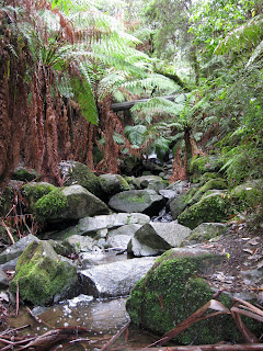
Look out on the left for a signed (sharp) left turn down some steps to a bridge leading over the top of the falls. I couldn’t find a spot with a good view of the falls at all, so unfortunately I didn’t get a good photo of them. However, the view over the falls to the mossy gully below was totally worth the walk anyway.
I had planned to return via Hillclimb and O’Donohue Tracks but much to my dismay, Hillclimb Track was closed for works. I decided to retun via the same route but I soon realised that there was a link track only a few hundred meters back, so I could still use O’donahue Track as a different return route. I’ve highlighted my intended route on my map (above) since I’m pretty sure that the Hillclimb Track closure is temporary.

Part of Sherbrooke Track

Sherbrooke Creek above the falls
I didn’t see much in the way of wildlife on this walk (probably due to the rain) but on my way back down Sherbrooke Road afterwards, I had to stop for a Lyrebird to cross the road.
Have you visited Sherbrooke Falls? If you have any stories, updates or corrections, please let us know by commenting below.


Thanks for the Info, been thinking about exploring the Dandenong hills.
No worries, Simon! Enjoy! 🙂
Cheers
Neil
Hi Neil,
I had been on the area last sunday (26-OCT-2014). I had started the trek from Coles Ridge Road on the Eastern Sherbrooke Forest near the Old Monbulk Road, Belgrave and took the Lipscombe Break. This lead to Monbulk Road and once you cross the road there is a car park which leads to the Hillclimb track. The Hillclimb track is completely open for walk and the bridge on top of Sherbrooke Falls is also open now. The other end of the bridge leads to Ridge Track. Continuing on Hillclimb track will lead you to Wattle Track and at the end of Wattle Track if you reach the main road by walking little distance on the Lloyd’s track, you can reach Alfred Nicholas Gardens, which is a nice one to have a look around.
I returned back the same way after having a walk inside the garden as I rely on public transport.
I also walked along the sherbrooke track to the picnic ground that you have mentioned and on the way back, could spot a black wallaby behind a fence.
It was quite a nice walk. Would be great if I could get a better map of that area.
Thanks,
Harihara Madavan
Thanks heaps for the much-needed update, Harihara! I really appreciate you posting these. There are a lot of places I rarely visit, so it’s very helpful for other readers. Glad you enjoyed the walk!
Cheers
Neil
Hi Neil, great blog! Just starting to explore Victoria (on foot :D)and your blog has been a gem. Just a quick update. We walked this track on 9 Mar 2013 and noticed that the track down to the bridge over the falls is currently closed for repairs. We peered over and it seemed that the vegetation had ccollapsed over the bridge. No idea when it will reopen. Thought I’d put it here so that others will know. Still a good walk though!
Hi Chrissy,
I’m so glad you’re loving the blog! Thanks for letting me know about the bridge. I’ll update the article. Much appreciated!
Cheers
Neil